New York State Celebrates the 200th Anniversary of the Gerrymander
Lee Hachadoorian on Mar 30th 2012
Colleagues at Center for Urban Research have posted a fun interactive map for visualizing the various New York State redistricting proposals. New York, like all states, is redrawing state and federal legislative districts based on the 2010 Census. So far, it’s not going so good. The proposals released by the legislature have been widely criticized for not preserving “communities of interest”, a common redistricting desideratum. The legislature was unable to agree on federal districts, and left that up to a federal court. State legislative districts were signed into law by Gov. Cuomo, in exchange for a legislative pledge to create a bipartisan redistricting panel for the next go round (i.e., 2020). But the redistricting reform that is shaping up has been criticized by a former New Yorker and current member of the California Citizens Redistricting Commission for, among other things, leaving final adoption in the hands of the legislature.
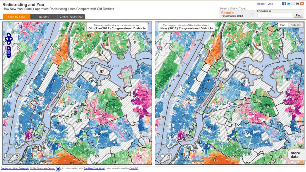
Race of course looms large in the redistricting process, and much of the state and federal courts’ focus is on satisfying the demands of the Voting Rights Act of 1965. Redistricting proposals have been rejected by courts both for drawing oddly shaped “majority minority” districts and for diluting minority voting power by fragmenting minority populations among majority White districts. But looking at the current redistricting proposals, I was most struck by the utter disregard for local political boundaries. Political boundaries often are coincident with physical boundaries, so districts that cross rivers while splitting islands and peninsulas, as we see in this view of part of New York City, also split and combine communities of interest in arbitrary ways.
In New York City I would venture to say that we think of ourselves first as New Yorkers, then by our neighborhood, then by the intermediate geography of the borough. The proposed and enacted districts, even the reasonably compact congressional districts set by the court, trash all of these possible geographies, joining Eastern Queens with parts of Nassau County, joining the North Bronx with parts of Westchester. With a target constituency of ~720,000 people, no possible district could encompass Staten Island’s 469,000 residents without including some piece of Brooklyn, Queens, or Manhattan. The arbitrary geographies of these districts, which don’t correspond with any geographic or political unit that voters identify with, probably contribute to voter confusion and voter apathy. So, while I am glad that good government groups like Common Cause are paying attention to the redistricting process, drawing “fair” districts only solves part of the problem.
One way to avoid the whole redistricting problem would be to adopt a system of proportional representation. There are different possible implementations of proportional representation, but under one such system, New York State voters would vote for a slate of candidates, probably by political party, to represent them in Congress. If 62% of New Yorkers voted Democratic and 37% voted Republican (roughly the vote from the 2008 presidential election), the state would send 17 Democrats and 10 Republicans to Congress. Of course, one of the claimed advantages of proportional representation is that people would be more likely to vote for third parties which more accurately matched their politics, since their vote would not be “thrown away” as it is in a winner-take-all system.
If we wanted to preserve local representation in Congress, another possibility would be to draw districts that match existing political units—counties, large cities, perhaps groups of small cities that chose to join together—but have the district representative’s vote be proportional to the district population. Instead of each representative getting one vote, the representative from Queens would get 2,230,722 votes in the legislature, while the representative from Manhattan would get 1,585,873 votes. Such a system would still have the problem of any winner-take-all system in that the minority party in each district would be represented in the legislature by someone who they voted against, but it partially solves the gerrymandering/communities of interest problem. It could also be seen as a first step towards a delegable proxy, wherein each person could vote on specific bills being considered by the legislature while the elected representative would be presumed to speak for those voters who had abstained from a specific vote.
The term gerrymandering, referring to the creation of bizarrely shaped districts for the purpose of securing a political advantage, arose in 1812. Two hundred years is long enough to have endured this silliness.
Filed in GIS,Governance | Comments Off on New York State Celebrates the 200th Anniversary of the Gerrymander